Saturday 22 February 2020

Blue Roads of America: a British Spy, a Confederate President and Cotton Cities of Mississippi and Georgia


We Brits sometimes ignorantly assume that the USA is a young country with little or no history. However, in my 40 years travelling in USA I rarely returned home without visiting a place with a history of which I had previously been ignorant. One lesson I learned was the crucial importance of rivers as the early highways of the United States.

Major John André
Let’s start with the tale of a British spy and the arch-villain of US history, Benedict Arnold. Our New Jersey friends, Chris and Bob Contillo, once took me for dinner to the ’76 House in Tappan, New York, formerly Yoast Mabie’s tavern, opened in 1668. Preserved in the basement is the prison cell where Major John André, head of the British Army’s spy service, spent his last days in 1780. André’s mission was to meet Arnold who, in exchange for a payment of £20,000, would arrange the surrender of West Point, which would have isolated New England from the rest of the rebellious American colonies.

André sailed up the Hudson river in a British naval vessel, and then was
Benedict Arnold
rowed in a small boat to his rendezvous by two local boatmen. After meeting Arnold, André made his escape, in civilian clothing, with papers that gave him a false identity, and others that described how to take West Point, all in Arnold’s hand. André seems not to have been a very capable spy. As he approached Tarrytown, New York, he bumped into three militiamen, whom he mistook for Hessians fighting for the British. André identified himself as a British officer and was promptly arrested. His captors took him to George Washington’s headquarters in Tappan where he was summarily tried and sentenced to death by hanging.

Since he died a failure, one might suspect that André’s reputation would be forever tarnished. However, he was apparently a handsome and dashing character, and popular culture soon started to create something of a legend around the major’s death. In 1798 André: a Tragedy in Five Acts, the first American tragedy on an American subject, written by William Dunlap, opened in New York City. Dunlap based his play on the English Romantic poet Anna Seward’s Monody on Major André, published in 1783. For those, like me, who do not know what a monody is, it is an ode sung in Greek tragedies to lament a death.

André's memorial in Westminster Abbey
Ninety nine years to the day after André’s death, the millionaire businessman Cyrus W. Field, who laid the first telegraph cable across the Atlantic in 1858, dedicated a granite monument in Tappan to the failed spy. However, by then André’s remains had already been disinterred and transferred to a rather grander monument in Westminster Abbey, which had been waiting for the gallant major’s return since 1782. Thus, despite the failure of his journey up the Hudson, André lies a hero in a building where many of the most significant Britons are honoured.
 
Field's monument to André in Tappan
Arnold's plaque in London
As for Arnold, probably the most reviled character in American history, he was rather better at escape than André. A blue plaque in London records, without a hint of irony, that “Major General Benedict Arnold American patriot resided here from 1796 until his death June 14, 1801.”


President Jefferson Davis

Another character with a rather mixed reputation is Jefferson Davis, the first and last president of the Confederacy. His Confederate White House is in Richmond, Virginia, hidden from all but the  most inquisitive visitor by a huge modern office block. My tour was led by a charming man with a wonderful southern accent, who proudly told his visitors that one of his ancestors had fought with Robert E. Lee. He clearly believed that the wrong side had won the War Between the States.
 
The Southern White House in Richmond, 19th century
Davis and his wife Varina lived in their White House from August 1861 to April 1865, when the
Lincoln in Richmond, Thomas Nast, woodcut, 1865
Confederates evacuated Richmond. After the Union troops had burned much of Richmond, Abraham Lincoln boarded a steamer on the Potomac River to the Chesapeake, and thence up the James River, to stroll through the capital of his bitter enemy. Davis was eventually captured as he fled with the papers and gold of the Confederacy. While his nemesis was soon to fall to an assassin’s bullet, Davis had a second career, after a brief spell in prison, touring gatherings of old Confederates to keep alive the Lost Cause, still lamented in the South to our day.

Varina Davis’ hometown was Natchez, Mississippi, set on top of a bluff above the Mississippi River. She was the daughter of a not very successful planter and slave owner. Her family home, the Briars was built in 1818, and is now a rather charming bed and breakfast, situated behind a very un-charming abandoned motel. A notice in the hallway proudly tells visitors that Jefferson Davis and Varina were married there in 1845.
 
The Briars, Natchez, home of Varina Davis, now a B&B
The Mississippi from Natchez Bluff
From the top of the bluff there are expansive views of low-lying land on the other side of the great river for miles, where slaves once toiled in the cotton fields. Natchez flourished as the place where Mississippi cotton planters could leave the heat of the cotton fields to relax in their town homes. I visited one of the homes. The charming Mississippi lady who was our guide told us of the history of the owners. The daughters were sent to Europe to acquire the required social skills, one of which was to play the piano. There was a pianoforte in the living room, which must have had a long and complicated journey from Europe.
 
The Rosalie Mansion in Natchez
Mammy's Cupboard, Natchez
Just outside Natchez is Mammy’s Cupboard, a diner in the form of a huge black mammie, whose enslaved human counterparts would have raised the cultured young daughters and sons of planter families. Customers enter the dining room through a door set into the Mammie’s skirt. The black mammie is  a classic stereotype, akin to the golliwog, but the Cupboard seems to escape censure for its racial overtones. The Cupboard is on highway 61, which parallels the highway of the planters’ day, known as the Natchez Trace. The Trace, a trail used by native Americans long before the arrival of Europeans, connected Nashville, Tennessee, from where the Cumberland River flows to the Ohio and the Mississippi, some 440 miles to the north, with Natchez. A number of mounds remind the traveller of the region’s pre-European past. Along this road,  from the early years of the 19th century travelled wagons of essential supplies and trade goods. Dotted along it were inns and trading posts.
 
Map of Natchez Trace
Natchez-Under-the Hill, first half of the 19th century
Not all goods travelled by wagon along the Trace. Wooden flatboats, powered by the Mississippi’s currents (no CO2 footprint) made the journey from Nashville to the landing at Natchez Under-the-Hill. Here the flatboat men sold the wood of their vessels to finance their trip home upriver, and a good deal of gambling, drinking and visits to the local brothels, away from the disapproving gaze of the planter families in their homes on the bluff above. Then the rivermen walked, or rode on horseback, to Nashville to begin their journey again.  
 
The Mississippi, and the Ohio flowing from Pittsburgh
Alvarado Avenue, La Belle, Missouri
To understand the economic geography and history of the USA one need only look at a map of its great rivers. The Ohio and the Mississippi flow north to south, and join their waters in Cairo, Illinois, providing the trade routes that drove the American economy. This lesson was impressed on me when I drove from Kirksville to Hannibal, Missouri, famous as the setting for Mark Twain’s novels. As I drove along state highway 6, I passed endless fields of corn, through towns such as Hurland (pop. 163), the rather more substantial La Belle (pop. 660), or the almost metropolitan Edina (pop. 1,176). My commuter train to London had a population that far exceeded that of most towns along the road. When I reached Hannibal, I realized that to get to any settlement of any size in Twain’s day the Mississippi riverboat was the only way to go. The arrival of the riverboat was a great event, since it brought goods, visitors and news from the growing cities. In Twain’s day Nashville was a city of some 7,000 souls. St Louis was home to fewer than 20,000 in 1840, but ten years later boomed to almost 78,000. Only about 1,000 residents lived in Hannibal. And inland for miles stretched farmland and the very occasional small settlement
Hannibal, Missouri, 1857

Rome, Georgia
Map of the Coosa river
Another southern town with a river history, and an historical connection to a political marriage is Rome, Georgia. The city was founded on the banks of the Coosa River in 1834 named for its seven hills. The Coosa flowed south to Mobile, Alabama, on the Gulf Coast. The slight inconvenience that the Rome was founded on land in the Cherokee was briskly resolved in 1838 by expelling the Cherokee to Oklahoma. Rome flourished as the port from which northern Georgian cotton planters could load their crop onto steamboats which sailed to Mobile, and thence to world markets. Prosperity ended when General Sherman’s troops marched into Georgia in 1864, destroying much of Rome’s productive capacity. Visitors to Rome are proudly told that President Woodrow Wilson met and married his wife Ellen, the daughter of a preacher, in Rome. Wilson was born in Staunton, Virginia, where his parents were slave owners, but spent most of his childhood in August, Georgia. His father was a founder of the Southern Presbyterian Church, which split from the Northern Presbyterians in 1861 because of a dispute concerning the loyalty of the church to the federal government. So, Ellen and Woodrow both had firm southern confederate roots.
First Lady Ellen Wilson

Another eminent lady of Rome was Martha McChesney Berry, the daughter of a wealthy cotton trader, who devoted her life to education. She started with a one-room in the abandoned Possum Trot church, and in 1902 founded Berry College, which I visited about 2006. Berry claims to have the largest contiguous college campus in the world: 27,000 acres of fields, forests, lakes and Lavender Mountain. The campus is home to some 2,000 students and perhaps 2,500 deer.
The former Possum Trot Church school
Berry College, Rome, Georgia

A modern visitor to Rome can visit the riverside and a few 19th-century buildings. Perhaps the most interesting sight in contemporary Rome is a bronze statue of Romulus and Remus being suckled by a wolf. The plinth carries a plaque in Latin, which in translation reads “This statue of the Capitoline Wolf, as a forecast of prosperity and glory, has been sent from Ancient Rome to New Rome during the consulship of Benito Mussolini in the year 1929.” The statue was temporarily removed in 1949, to protect from anti-Italian sentiment. The statue was proudly reinstated in 1952. Republican America may have cast off the oppressive rule of Old Europe’s monarchs, but the old culture of Europe continued to fascinate the new republic’s rough-hewn citizens long after they had won independence.
Mussolini's Romulus and Remus statue, outside City Hall, Rome Georgia


Tuesday 18 February 2020

Blue Roads of America: Indiana


I am not a fan of travel writing, but in the 1970s, while living in the USA, I enjoyed enormously a book by William Least Heat Moon, Blue Roads of America. His idea was to travel only on minor roads marked on maps in blue (the equivalent of British B roads or French D roads). For the last decade or so of my publishing career I worked closely with W. W. Norton, a fine employee-owned publishing house, in New York. The president of Norton, Drake McFeely, used to joke that I visited places in his country that he had never visited. I did not always drive on blue roads, but I came across many of the kinds of places that fascinated Least Heat Moon.
 
Newburgh, Indiana
Newburgh's claim to fame
I was a frequent visitor to Newburgh, Indiana, where it became a tradition that I would treat the family of my friend and author Ralph Larmann to a fish supper at The Tin Fish. Newburgh, home to some 3,300 people, ranges along the banks of the Ohio River, on the other side of which is Kentucky. The original Newburgh was founded in 1829 by Abner Luce. In 1841 the town merged with its neighbour to the east, Sprinklesburgh, founded, by a business man named John Sprinkle. Newburgh had two assets: its riverside location and a seam of coal to power steamboats. It soon became one of the largest ports on the Ohio, until, the railroad diverted business to nearby Evansville.

Adam R. Johnson
Newburgh’s claim to historical fame is that on 18 July 1862 it was the first town north of the Mason Dixon Line to surrender, rather ignominiously I must say, to the Confederates. The leader of the Newburgh Raid was Brigadier General Adam R. Johnson, the inventor of the Quaker cannon, first deployed in the capture of Newburgh. Johnson made two fake cannons from a blackened log and a stove pipe, placed on a hill on the Kentucky side of the river. The threat of Johnson’s “artillery” persuaded the Union commander of Newburgh’s garrison to surrender without firing a shot. Johnson is known to history as “Stove Pipe” Johnson.
 
Johnson's Quaker cannons aimed at Newburgh
The Harmonist granary at New Harmony
About 50 miles northwest of Newburgh is New Harmony, a town of fewer than 800 people, on the banks of the Wabash River, a tributary of the Ohio. In 1814 some 800 pietist Harmonists from Württenburg in Germany, led by George Rapp, bought 30,000 acres of land in the Indiana woods and named their town Harmony. The plan was to live in Christian perfection, in a highly ordered community, while they awaited the imminent second coming of Christ. The Rappites, as they were known, were industrious and soon were exporting agricultural produce and high quality wares down the Wabash to the Ohio and on to national and international markets. Chastity was obligatory. Unmarried men and women lived in separate dormitories. Couples with children who joined the group lived in family homes, but were required to become celibate. After 10 years, the Rappites decided to move on. They bought land on the Ohio, eighteen miles from Pittsburgh. The move was financed by selling Harmony to a Welsh utopian socialist, Robert Owen in 1825.
 
Richard Meier, the Atheneum Visitors Center, New Harmony
Owen had experimented with socialist ideas of running industrial enterprises in New Lanark, near Glasgow. He changed his American town’s name to New Harmony. Owen’s partner in his new enterprise was William McClure, a wealthy geologist, who attracted a number of prominent scholars and educationalists to New Harmony. Although Owen abandoned his experiment after only two years, New Harmony lived on as a centre of scholarship and learning. The town had a Thespian Society, a Jockey Club, and the Minerva Society, a literary club for young women. Today New Harmony survives as a cultural and historic centre run by the University of Southern Indiana. The Atheneum Visitors Center was designed by Richard Meier. Another distinguished architect, Philip Johnson, designed the New Harmony Roofless Church, an interdenominational space whose focus is a statue of The Descent of the Holy Spirit by Jacques Lipschitz.
 
Philip Johnson, New Harmony Roofless Church
Indiana War Memorial
Not exactly at the end of a blue road is Indianapolis, the state capital. The city proudly claims to be a patriotic city, with more monuments and memorials than any US city except for Washington, D.C. General John Pershing laid the cornerstone of the Indiana War Memorial, a huge building modelled after the Mausoleum at Halicarnassus, built in modern-day Turkey between 350 and 353BC as a tomb for Mausolus, a Persian Satrap, and his wife Artemisia II. Inside the memorial is a museum devoted to the USS Indianapolis, the ship that carried enriched uranium for Little Boy, the atomic bomb to be dropped on Hiroshima, to the US Air Force base on Tinian Island. Soon after leaving the island, the Indianapolis was sunk by a Japanese submarine. Hundreds of sailors died.
 
A scale model of the radio room of the USS Indianapolis
A curious item in the museum is a list of Indiana Firsts, that have nothing to do with the history of the Indianapolis. One first was the serving of the first Bloody Mary in the state in French Lick, a spa town. In the early 20th century its casinos attracted many celebrities, including Joe Louis, Irving Berlin and Al Capone.
Terre Haute railroad station
Another Indiana city with a French connection is Terre Haute, in the 19th century an important rail hub. I was told by a Norton colleague who lived there that bank robbers avoided Terre Haute because the railway tracks ran through the centre of town. A passing train could ruin the robber’s getaway plans.

About 60 miles northeast of Indianapolis, is Muncie, known as the most studied city in the USA because it was the subject a large-scale sociological study begun in 1920. I visited Muncie several times to talk to professors in the art department of Ball State University. The university takes its name from its main benefactors, the Ball family, founders of the most important business in Muncie’s history. The five brothers (William Charles, Frank Clayton, Lucius Lorenzo, Edmund Burke and George Alexander) founded their business in 1880 making home canning glass jars, known as Ball jars.
 
Ball State University, Muncie, Indiana
Like many industrialists of their time, the Ball family were collectors of art. The university art museum is named after David T Owsley, grandson of Frank, and an art historian who worked at the Metropolitan Museum in New York, the Museum of Fine Arts in Boston, the V&A in London, and the Carnegie Museum of Art in Pittsburgh. Frank seems to have started the family passion for art collecting by chance. In 1918 he and two of his daughters were in an elevator in the Plaza Hotel in New York. Frank asked the elevator operator why there was a large crowd on the ballroom floor. The operator replied that they had gathered for the auction of the works owned by a recently deceased collector. Frank had recently undergone eye surgery and was delighted that he could see clearly the art on sale, so he bought 70 paintings.
 
J. Ottis Adams, Nooning (The Gleaners), oil on canvas, 1886
Frank’s brother-in-law was the Hoosier Impressionist J. Ottis Adams, several of whose works are in.  the museum collection. Indianans are known as hoosiers, a nickname that dates back to at least 1830, but whose exact derivation is uncertain and the subject of many speculative explanations, not all of them flattering to hoosiers. One explanation attributes the term to the pugnacious character of early settlers who were fond of biting off the ears of opponents in a fight. Finding an ear on the floor of a tavern from last night’s fight, the question would be “Whose era”, hence hoosier. Another pugilistic explanation is that the state’s Ohio riverboat men  regularly succeeded in “hushing” (or trouncing) their opponents, and so were known as “hushers” which later became hoosiers.

Fortunately, on none of my visits to the Ohio waterfront in Evansville and Newburgh did I encounter any pugnacious hoosiers.

Friday 14 February 2020

The Brexit Project and The Future of the United Kingdom


The former Conservative Prime Minister David Cameron displayed a certain insouciance with regard to referenda. With little apparent consideration, he agreed to a referendum on Scottish independence to be held in 2014. Two years later he held a second referendum, in this case concerning the UK’s membership of the EU. In both cases, the referendum was a Yes or No vote, and a simple majority of one vote would suffice to decide the matter. In the case of the Scottish referendum, EU citizens resident in Scotland were entitled to vote. In theory, therefore, since a single vote could be conclusive, a single Spaniard, German, Pole etc, by casting a vote for independence, could have caused the dismemberment of the UK. True, this was a very remote possibility, but it seems to have given Mr Cameron no pause for thought.

Mr Cameron’s government and the No campaign during the Scottish referendum campaign emphasized two arguments very strongly. Firstly, if Scotland voted for independence the country would have voted to leave the EU, and the EU would be most unlikely to re-admit Scotland. Secondly, Scotland would not be able to use the pound as its currency. In effect, therefore, the UK government promised Scots that they could remain in the EU with the pound as their currency provided they voted No. As it turned out, the No vote won by some 10% points.

A year after persuading Scots to vote No to independence in order to remain a member of the EU, Mr Cameron called an In/Out referendum concerning EU membership. Again, the question required a simple Yes/No answer. EU citizens could not vote in this referendum, but in other respects the rules were the same: one vote could decide the outcome. And again, Mr Cameron, had nonchalantly allowed a fundamental constitutional change that could be decided by the smallest of majorities. In the event, the No vote won by almost 4% points, or a little more than 1 million votes.

Now, the Scots voted by a majority of about 33% to remain in the EU. In Northern Ireland a majority also voted to remain in the EU. But England and Wales voted to leave. Thus, Brexit is an English project (with the exception of London’s population of almost 9 million), with Welsh support, over the opposition of the Scots and Northern Irish. The population of England outside London is some 46 million of a UK total of 66 million. Thus, what non-metropolitan England wants is what the whole country gets. This created complicated situations, which include the possible independence of Scotland or Northern Ireland, or both from the UK. Recent events have further complicated the picture.

In the December UK general election, the Scottish National Party (SNP) increased its number of seats in Parliament, while the Conservatives lost seats and the Labour Party, which once dominated Scottish politics, was reduced to a single seat. The Liberal Democrats lost the seat of its brand-new leader. The SNP has been the governing party in Scotland for thirteen years. Thus, Scotland is ruled by a pro-EU, pro-independence party, while the government in London opposes independence and is pursuing the most aggressive form of Brexit possible. The SNP, of course, demands a second independence referendum. Prime Minister Johnson has not handled this matter with any delicacy. His response is that there will be no referendum and that the SNP is doing a rotten job of governing Scotland and should concentrate on improving its performance. You do not need to be a PR genius to paint this to Scots as typical English arrogance. It will certainly not reduce sentiment in favour of  independence.

Meanwhile, things have become more complicated in Northern Ireland, not just because of Brexit and the general election result in the UK, but because the general election in the Republic of Ireland has added an extra complication.

Since my friends beyond the UK may not be too familiar with Northern Ireland, it is worth digressing to explain that politics there operate to entirely different rules and dynamics than in the rest of the UK. Firstly, this is the only part of the UK in which none of the national parties runs   for office: all candidates represent local parties, broadly speaking either Unionist or Nationalist. The Unionists are traditionally allies of Mr Johnson’s Conservative and Unionist Party, to give it is full name, although he has succeeded in upsetting them with his EU withdrawal agreement. The Nationalists are implacably opposed and those who represent Sinn Féin (the largest Nationalist party) refuse to take their seats in Parliament because to do so they must swear loyalty to the British monarch. Sinn Féin is resolutely opposed to Brexit, not least because it leaves the North out of the EU but the South firmly in the EU.

Northern Irish politics has one other unusual feature. It is possible for Northern Irish political parties (that is to say Republican parties, not Unionist) to run for office in the Republic of Ireland, but not vice versa. To exaggerate the point, my American friends might imagine a scenario in which Mexican political parties can run for office in the USA, and indeed occupy the White House, but the Democratic and Republican parties cannot field candidates south of the border. Imagine Mr Trump’s Tweets on the matter.

Well, something almost like that, reduced to the scale of a tiny nation (a little less than 5 million people), has just happened in the Republic of Ireland’s general election. To the astonishment of even its own leaders, Sinn Féin has won the largest number of votes and the second largest number of seats. The Republic is governed by coalition governments. It is theoretically possible, although practically unlikely, that Sinn Féin could organize a governing coalition and become the principal governing party.

The leader of Sinn Féin has declared her intention to make a “Border Poll” her condition for a coalition. A border poll, or referendum, is a provision of the Good Friday Agreement of 1999, which ended many years of the violence of “The Troubles”. Essentially, the Agreement states that, if sentiment in the North comes to favour reunification, a referendum can be held. The key here is that the Agreement is an international treaty between the UK, the communities of Northern Ireland, and the Republic of Ireland, which therefore involves the EU since the republic remains a member. Sinn Féin and the Irish government do not have the sole power to call a referendum, but opposition to Brexit and recent election results in the North, have shifted opinion further in the direction of reunification. If Sinn Féin forms part of the government of the Republic, the likelihood of a referendum increases.

The Irish and British general elections happened only two months apart in the two countries most profoundly affected by Brexit. However, while the Conservatives succeeded in making the UK election about nothing but Brexit, the Irish result was the result of other concerns, principally an acute housing shortage and access to health care in the Republic, which the ruling parties had been ineffective in addressing. Sinn Féin campaigned very effectively on these issues.

Housing is, or rather should be, a critical issue in the UK where the cost and availability of housing is a long-standing problem, which the party in power has not addressed effectively in the last ten years. In addition, the National Health Service is under increasingly severe stress, and a reform of Social Care has been promised repeatedly, but not delivered, for the past decade. However, incompetent opposition leaders allowed the UK election to be called for the single reason of Brexit. So far, Mr Johnson’s government’s grand spending announcements have focused principally on transport initiatives that cost billions of pounds. While increased spending on the NHS has bene promised, a solution of the Social Care crisis is still in the realms of rhetoric, rather than action. It is worth noting that the performance of Northern Ireland’s NHS is scandalously bad, principally because of a long political dispute between Sinn Féin and the Democratic Unionist Party. Thus, Sinn Féin lost votes in the North because it handled the health care issue, while it won votes on the same issue in the South.

Brexit, which is now essentially a project of the Conservative and Unionist party, increases the possibility of one or two parts of the UK becoming independent. We Brits are familiar with the tendency of Americans to call us all English. I am both English and British. I have friends and neighbours who are Scots and (Northern) Irish. Whether they will remain British is another matter. I hope that they do.

Thursday 6 February 2020

“There’s a worm in my blanket”, “where is your husband” and other useful phrases


In the Easter vacation of 1971, instead of heading home to Ipswich, I caught a bus from Cambridge to Scotland. My destination was the University of St Andrews, where I was to take a crash course in Quechua at the Centre for Latin American Linguistic Studies, founded by Douglas Gifford in 1969. Douglas was a large man with an even larger character. He was born in Buenos Aires (his middle name was Juan) and initially specialized in Medieval Spanish. He was also a keen musician and conductor of a choir. I stayed in Douglas’ book-lined house and spent my days drilling myself in Quechua vocabulary, grammar and pronunciation. All I can now recall are two phrases: Qata ukhupi kuru kashan (“there’s a worm in my blanket”), a pronunciation exercise to learn the different consonant forms (glottal stop, aspirated and unaspirated), and marido ukhupi (“where is your husband”), which was useful as will soon be apparent.

The reason for my course in the indigenous language of Peru was that I had been enlisted as the
General Velasco (saluting) with Salvador Allende of Chile (left)
interpreter for two geographers who were to study the agrarian reform programme of the revolutionary military government of Juan Velasco Alvarado in the Urubamba Valley and the Pampa de Anta in the south of the country. We accidentally met Velasco and his cabinet during the celebrations of the 150th anniversary of independence in Lima. We joined a long line of locals who we thought were queueing to see the presidential palace. In fact, they were waiting their turn to be greeted by Velasco and his cabinet. The generals who ruled Peru were clearly surprised to meet three Englishmen, especially my companions who were preternaturally tall by Peruvian standards.

Velasco’s government lasted from 1968 to 1975. Our visit to Peru was too brief to understand in any detail the country’s politics. We did learn, the day after we met Velasco, that there was opposition. We were in a bookshop in central Lima buying a Quechua dictionary. We heard a good deal of shouting and almost immediately a water canon sent a bolt of water almost directly into the bookshop. Fortunately, it missed us and my dictionary, but a good part of the stock was destroyed. Shortly afterwards, when we reached Cuzco, the ancient capital, we learned that the university students were on strike. As we toured the sights of central Cuzco, we noticed trucks full of soldiers in the streets around the Plaza de Armas, the main square. The next day the local paper informed us that the army had attacked the university campus with tanks and gunfire from planes.
 
Cuzco: the Plaza de Armas and cathedral in the centre
Mexico and Peru have some things in common. They were both the location of important civilizations long before the Spanish arrived with permission from the Pope to conquer and evangelize. The Aztec, Tarascan, Mayan and other ancient civilizations left marks on Mexican society that are still evident today. In Peru a single indigenous group dominated in the 16th century, the Incas, whose language was Quechua. While ancient Mexican civilizations were based on the cultivation of maize, Andean cultures relied on the potato, of which they had many varieties. Another difference between ancient Mexico and Peru was that, unlike the Mexico, where there we
An alpaca herd
no domestic animals larger than a turkey, Peruvians had domesticated large animals (camelids such as llamas, alpacas and vicuñas) that could be used as beasts of burden or sources of wool (Mexicans had cotton but no wool). The indigenous element of Peruvian society is much more striking today than in Mexico.
Indigenous women
People in indigenous clothing, especially women wearing top or bowler hats and voluminous skirts, are much more visible and Quechua has survived more vigorously than Aztec Náhuatl.


We were based in Calca not far from Cuzco in southern Peru, initially on a mission farm run by a couple from Northern Ireland, and then a house that the mission owned in town. The setting was quite stunning: the river, lined by eucalyptus tress for many stretches, runs thourh a valley surrounded by snow-tipped mountains. We wandered up and down the valley interviewing farm workers and landowners about the reform programme. I would introduce myself in Quechua and then, hoping that my interviewees were bilingual, would ask questions in Spanish.
A bowl of chicha
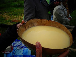
Workers in the fields would invariably offer us a drink of chicha, an alcoholic beverage made by chewing maize kernels and spitting them out to ferment. The two geographers found chicha quite repellent, so I spent many days drinking cup after cup of chicha as we progressed along the valley until I could hold no more. If we came upon the lady of the house, my phrase marido ukhupi would come in handy.

Our interviewees included the young mayor of a village whose trade was mending ploughs. His adobe home was decorated with posters of Che Guevara, Marx and Lenin. He showed us a detailed census of his village carried out by students from the University of Cuzco. Later we met the local landowner, who lived in a substantial house with his unmarried daughter. They had a rather elegant grand piano in their living room: how it made its way far into the Andes I had no idea. The landowner, naturally, described the mayor and his supporters as lazy thieves.

Although Quechua was the native tongue of the indigenous population, the official language of Peru was Spanish. I had learned in our first days in Lima that Peruvians of the upper classes would not deign to speak Quechua, and would congratulate me effusively on my elegant Castilian. Not “Spanish”,  but Castilian, the prestige dialect of the Spanish motherland. Language, ethnicity and class were inseparable, as an incident we witnessed on the Pampa de Anta demonstrated.

A general view of Anta
A pampa is a treeless plain, in the case of Anta high up in the Andes. We travelled there by local bus to visit the administrator in charge of the local agrarian reform programme. As we waited outside his office with a large number of indigenous men, a smartly-dressed fair-skinned woman with an equally well-dressed young daughter entered and made herself known to a secretary. She was instantly ushered into the administrator’s office, leaving the rest of us to wait until she had finished her business. I assumed that she was a landowner, certainly not a peasant. In any case, her ethnicity and Spanish tongue guaranteed that she did not need to wait like the rest of us.

The Incas, who had built cities, roads, storehouses and a powerful Andean empire until Francisco Pizarro led his group of Spanish adventurers to conquer Peru 1528-1532. The Inca heritage attracts large numbers of tourists. Visitors to the ancient Inca capital Cuzco cannot fail to notice that the structures that the Spanish conquerors erected on the ruins of the city sit atop massive Inca stone walls, a fitting metaphor for the conquest. Inca masons were highly skilled.
Inca stonework in Cuzco
They cut massive blocks of stone so precisely that one cannot insert even a thin blade between them. The famous “lost city of the Incas”, Machu Picchu exhibits similarly impressive stonework.

The Quechua people of the Urubamba worked the fields of the valley floor or the terraces that climbed the mountainsides with very little technological help. The flat land could be cultivated with a simple plough drawn by an animal. One day we climbed the terraces of Urubamba town to a tiny settlement high above the valley floor where the fields seemed almost vertical.
A chaki taklla
Here the only feasible implement was the chaki taklla, a digging stick of the type used four centuries ago by the Incas. In short, the Quechua laboured hard for very little financial reward. Life was made tolerable, partly by drinking chicha, and also by chewing the leaves of the coca tree, which numbed the senses.

While we were in Calca, the town held its annual fiesta. The square filled with food stalls and large cauldrons of hot, sweet bean chicha coloured with a livid purple dye. A good many revellers were quite drunk by the time of the highlight of the evening, the firework display. The fireworks consisted of a variety of models such as battleships or tanks on platforms set atop a pole held by one man while another lit the fuse. The height of the poles was designed to direct the fireworks over the heads of the crowd. Now, in 1970s Peru I was tall. My companions, however, were so tall that those in charge of the fireworks could not have made allowance for their presence. As bolts of fires shot straight at them they were forced to duck down and miss most of the display.

Drunkenness has deep cultural roots in Peru. The Incas held public ceremonies in the large main square of Cuzco and rewarded their subjects with great quantities of chicha. A curious feature of Inca society was the preservation of dead members of the ruling group as mummies, who were given their own homes and household staff to look after them. The mummies presided in silence over the bibulous celebrations in Cuzco. The Spanish, afraid of the symbolic powers of the mummies, seized them and sent them to Lima, the new colonial capital. A few years ago, I listened to a lecture by an American archaeologist who wondered whether the mummies had survived centuries of colonial rule and modern urban development. Alas, he failed to find a single mummy.
Sacrificial Inca mummies, not of the royal sort

After we had finished our research in the Urubamba valley and on Anta, we decided to visit Bolivia.
A reed village on Lake Titicaca
Our first stop was Lake Titicaca, which sits astride the Peruvian-Bolivian border. Tourists go to Titicaca to see the reed boats and villages of houses constructed of reeds on reed islands. We had intended to cross the border into Bolivia the next day but, as it happened, president Juan José Torres, like Velasco Alvarado a left-wing military man, was deposed by another military leader, Hugo Banzer, supported by the USA and the Brazilian military dictators, and the borders were closed.

As for General Velasco Alvarado, his military colleagues deposed him in 1975 and he died quietly in 1977.